| Tue 28 Jul |
☀️ 04:07
🌙 21:07 |
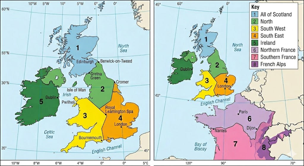
1. Scotland |
LIFR/ LIFR~421ft · 9nm |
MVFR/ MVFR~1,508ft · 22nm |
Precip 100% probability; Gusts 34kt |
| 2. North |
IFR/ IFR~804ft · 9nm |
MVFR/ MVFR~1,780ft · 12nm |
AM: Wind 242/10kt G20kt · Frz 12,782ft · Precip 15%; PM: Wind 252/11kt G21kt · Frz 12,460ft · Precip 5% |
| 3. SW |
MVFR/ MVFR~1,020ft · 11nm |
VFR/ VFR~4,222ft · 13nm |
AM: Wind 261/5kt G12kt · Frz 13,523ft; PM: Wind 253/5kt G14kt · Frz 13,083ft |
| 4. SE |
VFR/ VFRNo ceil · 14nm |
VFR/ VFR~6,779ft · 15nm |
AM: Wind 231/7kt G16kt · Frz 13,956ft; PM: Wind 239/8kt G18kt · Frz 13,576ft |
| Wed 29 Jul |
☀️ 04:09
🌙 21:05 |
1. Scotland |
LIFR/ LIFR~272ft · 9nm |
MVFR/ MVFR~1,910ft · 23nm |
Precip 61% probability; Precip 74% probability |
| 2. North |
MVFR/ MVFR~1,606ft · 15nm |
MVFR/ MVFR~2,090ft · 18nm |
AM: Wind 240/7kt G15kt · Frz 11,981ft · Precip 10%; PM: Wind 265/8kt G17kt · Frz 11,778ft · Precip 43% |
| 3. SW |
VFR/ VFR~3,439ft · 12nm |
VFR/ VFRNo ceil · 21nm |
AM: Wind 264/4kt G15kt · Frz 12,421ft; PM: Wind 266/10kt G22kt · Frz 13,051ft |
| 4. SE |
VFR/ VFRNo ceil · 12nm |
VFR/ IFRNo ceil · 19nm |
Showers/instability |
| Thu 30 Jul |
☀️ 04:11
🌙 21:03 |
1. Scotland |
MVFR/ MVFR~1,873ft · 6nm |
IFR/ IFR~793ft · 6nm |
Precip 93% probability |
| 2. North |
VFR/ VFR~3,551ft · 11nm |
VFR/ VFR~3,249ft · 10nm |
Gusts 26kt |
| 3. SW |
VFR/ VFRNo ceil · 13nm |
VFR/ VFRNo ceil · 14nm |
AM: Wind 273/8kt G18kt · Frz 99,999ft · Precip 10%; PM: Wind 263/10kt G21kt · Frz 99,999ft |
| 4. SE |
VFR/ VFRNo ceil · 12nm |
VFR/ VFRNo ceil · 12nm |
AM: Wind 268/7kt G20kt · Frz 99,999ft; PM: Wind 263/10kt G21kt · Frz 99,999ft · Precip 11% |
| Fri 31 Jul |
☀️ 04:13
🌙 21:01 |
1. Scotland |
MVFR/ MVFR~2,138ft · 9nm |
MVFR/ MVFR~1,498ft · 5nm |
Vis 4.6nm (haze/reduced); Precip 75% probability |
| 2. North |
VFR/ VFRNo ceil · 12nm |
VFR/ VFRNo ceil · 13nm |
AM: Wind 205/6kt G18kt · Frz 99,999ft · Precip 42%; PM: Wind 263/8kt G19kt · Frz 99,999ft · Precip 30% |
| 3. SW |
VFR/ VFRNo ceil · 13nm |
VFR/ VFRNo ceil · 14nm |
AM: Wind 144/2kt G8kt · Frz 99,999ft; PM: Wind 221/4kt G12kt · Frz 99,999ft · Precip 5% |
| 4. SE |
VFR/ VFRNo ceil · 14nm |
VFR/ VFRNo ceil · 15nm |
AM: Wind 335/3kt G12kt · Frz 99,999ft; PM: Wind 292/3kt G12kt · Frz 99,999ft |
| Sat 01 Aug |
☀️ 04:15
🌙 20:59 |
1. Scotland |
MVFR/ MVFR~2,734ft · 12nm |
VFR/ VFR~3,573ft · 12nm |
AM: Wind 230/10kt G20kt · Frz 99,999ft · Precip 23%; PM: Wind 249/9kt G18kt · Frz 99,999ft · Precip 39% |
| 2. North |
LIFR/ LIFR~357ft · 2nm |
MVFR/ MVFR~1,001ft · 4nm |
Vis 4.0nm (haze/reduced) |
| 3. SW |
MVFR/ MVFR~2,377ft · 11nm |
VFR/ VFRNo ceil · 13nm |
AM: Wind 237/5kt G15kt · Frz 99,999ft; PM: Wind 257/8kt G18kt · Frz 99,999ft |
| 4. SE |
VFR/ VFRNo ceil · 14nm |
VFR/ VFRNo ceil · 14nm |
AM: Wind 172/4kt G13kt · Frz 99,999ft; PM: Wind 225/7kt G17kt · Frz 99,999ft |
| Sun 02 Aug |
☀️ 04:17
🌙 20:57 |
1. Scotland |
MVFR/ MVFR~2,658ft · 9nm |
VFR/ VFR~3,543ft · 13nm |
AM: Wind 242/3kt G11kt · Frz 99,999ft · Precip 18%; PM: Wind 278/5kt G13kt · Frz 99,999ft · Precip 45% |
| 2. North |
MVFR/ MVFR~1,659ft · 13nm |
VFR/ VFR~4,049ft · 13nm |
AM: Wind 054/3kt G9kt · Frz 99,999ft · Precip 12%; PM: Wind 095/6kt G17kt · Frz 99,999ft · Precip 13% |
| 3. SW |
IFR/ IFR~819ft · 5nm |
MVFR/ IFR~2,667ft · 11nm |
Showers/instability |
| 4. SE |
VFR/ VFR~3,054ft · 9nm |
MVFR/ IFR~1,119ft · 5nm |
Showers/instability; Vis 4.6nm (haze/reduced) |
| Mon 03 Aug |
☀️ 04:19
🌙 20:55 |
1. Scotland |
MVFR/ MVFR~1,379ft · 10nm |
VFR/ VFR~3,045ft · 30nm |
AM: Wind 328/5kt G12kt · Frz 99,999ft · Precip 13%; PM: Wind 276/6kt G14kt · Frz 99,999ft · Precip 21% |
| 2. North |
VFR/ VFR~3,241ft · 14nm |
VFR/ VFRNo ceil · 19nm |
AM: Wind 289/3kt G10kt · Frz 99,999ft · Precip 9%; PM: Wind 300/3kt G11kt · Frz 99,999ft · Precip 15% |
| 3. SW |
VFR/ VFRNo ceil · 16nm |
VFR/ VFRNo ceil · 30nm |
AM: Wind 316/2kt G7kt · Frz 99,999ft; PM: Wind 205/3kt G13kt · Frz 99,999ft · Precip 5% |
| 4. SE |
VFR/ VFR~4,151ft · 14nm |
VFR/ VFRNo ceil · 25nm |
AM: Wind 294/5kt G14kt · Frz 99,999ft · Precip 6%; PM: Wind 118/8kt G20kt · Frz 99,999ft · Precip 6% |